Note
Go to the end to download the full example code.
Magnetic Raster Dataset
These magnetic data channels were pulled from the Wisconsin SkyTEM example in this repository to demonstrate the relatively simple case of gridded raster files.
Source Reference: Minsley, B.J, Bloss, B.R., Hart, D.J., Fitzpatrick, W., Muldoon, M.A., Stewart, E.K., Hunt, R.J., James, S.R., Foks, N.L., and Komiskey, M.J., 2022, Airborne electromagnetic and magnetic survey data, northeast Wisconsin (ver. 1.1, June 2022): U.S. Geological Survey data release, https://doi.org/10.5066/P93SY9LI.
import matplotlib.pyplot as plt
from os.path import join
import gspy
from gspy import Survey
import warnings
warnings.filterwarnings('ignore')
Initialize the Survey
# Path to example files
data_path = '..//data_files//magnetics'

# Survey metadata file
metadata = join(data_path, "WI_Magnetics_survey_md.yml")

# Establish the Survey
survey = Survey.from_dict(metadata)
Survey YAML file
 1dataset_attrs:
 2    title: Magnetic data from SkyTEM Airborne Electromagnetic (AEM) Survey, Northeast Wisconsin Bedrock Mapping
 3    institution: USGS Geology, Geophysics, and Geochemistry Science Center
 4    source:  SkyTEM raw data, USGS processed data
 5    history: (1) Data acquisition 01/2021 - 02/2021 by SkyTEM Canada Inc.; (2) AEM and magnetic data processing by SkyTEM Canada Inc. 02/2021 - 03/2021; raw and minimally processed AEM data, and processed magnetic data, received by USGS from SkyTEM Canada Inc 03/2021; Minimally processed AEM data exported to netCDF /tabular/0 group 11/2021; (3) Minimally processed binary data and system response information received from the contractor were imported into the Aarhus Workbench software (v 6.0.1.0) where data were processed by USGS 03/2021 - 06/2021. Processed AEM data exported to netCDF /tabular/1 group 11/2021; (4) Processed data were inverted in Aarhus Workbench software using laterally constrained inversion to recover 40-layer fixed depth blocky resistivity models by USGS 03/2021 - 06/2021; Inverted resistivity models exported to netCDF /tabular/2 group 11/2021. (5) Resistivity models were imported into the Geoscene3D software (v. 12.0.0.680) and points were generated at the first depth where resistivity exceeded 325 ohm-meters. These points were visually inspected and manually adjusted in selected areas to produce an AEM-derived estmiate of the elevation of the top of bedrock by USGS together with WGNHS 06/2021 - 07/2021. Points were exported to netCDF /tabular/3 group 11/2021. (6) Bedrock elevation points were interpolated using kriging in Geoscene3D software to produce a regular bedrock elevation grid 07/2021. (7) A bedrock depth grid was calculated in QGIS software (v. 3.14.1-Pi) by subtracting the bedrock elevation from land surface elevation. (8) Bedrock elevation, bedrock depth, and SkyTEM-provided magnetic grids were aligned to a common 100m x 100m grid and exported to netCDF /raster/0 group 11/2021.
 6    references: Minsley, Burke J., B.R. Bloss, D.J. Hart, W. Fitzpatrick, M.A. Muldoon, E.K. Stewart, R.J. Hunt, S.R. James, N.L. Foks, and M.J. Komiskey, 2021, Airborne electromagnetic and magnetic survey data, northeast Wisconsin, 2021, U.S. Geological Survey data release, https://doi.org/10.5066/P93SY9LI.
 7    comment: This dataset includes minimally processed (raw) AEM and raw/processed magnetic data provided by SkyTEM
 8    summary: Magnetic survey data were collected during January and February 2021 over a distance of 3,170 line kilometers in northeast Wisconsin. These data were collected in support of an effort to improve estimates of depth to bedrock through a collaborative project between the U.S. Geological Survey (USGS), Wisconsin Department of Agriculture, Trade, and Consumer Protection (DATCP), and Wisconsin Geological and Natural History Survey (WGNHS). Data were acquired by SkyTEM Canada Inc. with the SkyTEM 304M time-domain helicopter-borne electromagnetic system together with a Geometrics G822A cesium vapor magnetometer. The survey was acquired at a nominal flight height of 30 - 40 m above terrain along parallel flight lines oriented northwest-southeast with nominal line spacing of 0.5 miles (800 m). AEM data were inverted to produce models of electrical resistivity along flight paths, with typical depth of investigation up to about 300 m and 1 - 2 m near-surface resolution. Shallow resistivity transitions were used to estimate depth to bedrock across the survey area.
 9    content: Wisconsin SkyTEM survey information
10
11survey_information:
12    contractor_project_number: 20022
13    contractor: SkyTEM Canada Inc
14    client: U.S. Geological Survey
15    survey_type: EM/Mag
16    survey_area_name: Northeast Wisconsin Bedrock Mapping
17    state: WI
18    country: USA
19    acquisition_start: 20210117
20    acquisition_end: 20210207
21    survey_attributes_units: SI
22
23spatial_ref:
24    wkid: 3071
25    authority: EPSG
26    vertical_crs: NAVD88
27
28flightline_information:
29    traverse_line_spacing: 800 m
30    traverse_line_direction: nw-se
31    tie_line_spacing: n/a
32    tie_line_direction: n/a
33    nominal_terrain_clearance: 30 m
34    final_line_kilometers: 3170 km
35    traverse_line_numbers: 100101 - 115201
36    repeat_line_numbers: 920001 - 920006
37    pre_zero_line_numbers: n/a
38    post_zero_line_numbers: n/a
39
40survey_equipment:
41    aircraft: Eurocopter Astar 350 B3
42    magnetometer: Geometrics G822A, Kroum KMAG4 counter
43    magnetometer_installation: Front of transmitter frame
44    radar_altimeter_system: n/a
45    radar_altimeter_sample_rate: n/a
46    laser_altimeter_system: MDL ILM 300R (2)
47    laser_altimeter_sample_rate: 0.033 s
48    navigation_system: Real-time differential GPS Trimble Bullet III
49    navigation_sample_rate: 1.0 s
50    acquisition_system: skytem
Create a Data Branch
data_container = survey.gs.add_container('magnetic_data', **dict(content = "raw flightline and gridded magnetic data", comment = "grids were contractor-derived"))
Add the raw magnetic data to the branch
# Import raw magnetic data from CSV-format.
d_data1 = join(data_path, 'WI_Magnetics.csv')
d_supp1 = join(data_path, 'WI_Magnetics_raw_data_md.yml')
rd = data_container.gs.add(key='raw_data', data=d_data1, metadata_file=d_supp1)
Raw Magnetic Data YAML file
  1dataset_attrs:
  2    content: raw data
  3    comment: Contains flightline magnetic data
  4    type: data
  5    structure: tabular
  6    mode: airborne
  7    method: magnetic, total magnetic field
  8    instrument: cesium vapour
  9
 10magnetic_system:
 11    type: system
 12    mode: airborne
 13    method: magnetic
 14    instrument: Geometrics G-822A cesium‑vapor magnetometer
 15
 16    prefixes: ['base_magnetometer']
 17
 18    dimensions:
 19        base_mag_locations:
 20            standard_name: base_mag_locations
 21            long_name: Base Magnetometer Location Index Numbers
 22            units: not_defined
 23            missing_value: not_defined
 24            centers: [1, 2]
 25            discrete: True
 26
 27    variables:
 28
 29        transmitter:
 30            label: passive
 31            description: No artificial magnetic transmitter was used. The system measures the scalar Larmor precession frequency induced by the Earth's magnetic field.
 32
 33        receiver:
 34            label: scalar_magnetometer
 35            sensor_type: cesium-vapor split-beam
 36            sensor_model: G-822A
 37            sensor_manufacturer: Geometrics
 38            description: Scalar cesium-vapor magnetometer mounted in the aircraft tail stinger. Measures total magnetic field through Larmor precession frequency.
 39            orientation: Tail-stinger mounted; scalar measurement independent of orientation.
 40            coordinates: not_reported
 41            lag_correction: Lag was negligible and no lag correction was applied
 42            heading_correction: Heading was negligible and no heading correction was applied
 43
 44        couplet:
 45            passive_scalar_pair:
 46            transmitters: [passive]
 47            receivers: [scalar_magnetometer]
 48            description: The magnetic measurement system consists of the Earth's field as a passive transmitter and a single scalar magnetometer mounted in the tail stinger.
 49
 50        base_magnetometer:
 51            label: base_magnetometer
 52            description: The base station magnetometer was placed in a location of low magnetic gradient, away from electrical transmission lines and moving metallic objects, such as motor vehicles and aircrafts.
 53
 54            location_names:
 55                values: ["Door County", "Manitowoc"]
 56                dimensions: 'base_mag_locations'
 57
 58            values:
 59                values: [54538, 54194.7]
 60                units: nT
 61                dimensions: 'base_mag_locations'
 62
 63            latitude:
 64                values: [44.849335, 44.127998]
 65                long_name: Latitude in WGS84
 66                units: decial degrees
 67                dimensions: 'base_mag_locations'
 68
 69            longitude:
 70                values: [87.422440, 87.685524]
 71                long_name: Longitude in WGS84
 72                units: decial degrees
 73                dimensions: 'base_mag_locations'
 74
 75            elevation:
 76                values: [178.1, 164.4]
 77                long_name: Elevation
 78                datum: WGS84
 79                units: m
 80                dimensions: 'base_mag_locations'
 81
 82        diurnal_correction: Diurnal signal removed using 3 second Fraser low-pass filter and subtracting base-station magnetometer values.
 83        tieline_levelling: No tie line-leveling were applied
 84        microlevelling: No micro-levelling were applied
 85        igrf_model_date: "2015, 15th generation"
 86        igrf_model_location: variable according to GPS WGS84 longitude and latitude
 87        igrf_model_height: variable according to magnetic sensor altitude derived from DGPS data
 88
 89coordinates:
 90    x: E_Nad83
 91    y: N_Nad83
 92    z: DEM
 93
 94variables:
 95    E_Nad83:
 96        standard_name: easting_nad83
 97        long_name: Easting, Wisconsin Transverse Mercator (WTM), North American Datum of 1983 (NAD83)
 98        units: meter
 99        missing_value: not_defined
100        axis: x
101
102    N_Nad83:
103        standard_name: northing_nad83
104        long_name: Northing, Wisconsin Transverse Mercator (WTM), North American Datum of 1983 (NAD83)
105        units: meter
106        missing_value: not_defined
107        axis: y
108
109    Alt:
110        standard_name: altitude
111        long_name: DGPS instrument altitude
112        units: meter
113        missing_value: not_defined
114
115    Base_Mag:
116        standard_name: base_magnetometer
117        long_name: Raw magnetic base station data
118        units: nanoTesla
119        missing_value: -9999.99
120
121    Date:
122        standard_name: date
123        long_name: Date, yyyy/mm/dd
124        units: not_defined
125        missing_value: not_defined
126
127    dec:
128        standard_name: decliniation
129        long_name: IGRF declination
130        units: degree
131        missing_value: not_defined
132
133    DEM:
134        standard_name: dem
135        long_name: Digital elevation model
136        units: meter
137        missing_value: not_defined
138        axis: Z
139        positive: up
140        datum: North American Vertical Datum of 1988 (NAVD88)
141
142    Diurnal:
143        standard_name: magnetic_diurnal
144        long_name: Magnetic base station diurnal variation
145        units: nanoTesla
146        missing_value: not_defined
147
148    Fid:
149        standard_name: fiducial
150        long_name: Unique fiducial number
151        units: not_defined
152        missing_value: not_defined
153
154    Height:
155        standard_name: instrument_height
156        long_name: Instrument height above ground
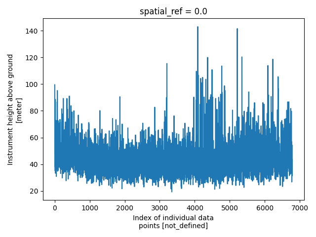
157        units: meter
158        missing_value: not_defined
159
160    igrf:
161        standard_name: magnetic_igrf_model
162        long_name: Magnetic IGRF value from 2015 model
163        units: nanoTesla
164        missing_value: not_defined
165
166    inc:
167        standard_name: inclination
168        long_name: IGRF inclination
169        units: degree
170        missing_value: not_defined
171
172    Lat:
173        standard_name: latitude
174        long_name: Latitude, World Geodetic System of 1984 (WGS84)
175        units: degree
176        missing_value: not_defined
177
178    Line:
179        standard_name: line
180        long_name: Line number
181        units: not_defined
182        missing_value: not_defined
183
184    Lon:
185        standard_name: longitude
186        long_name: Longitude, World Geodetic System of 1984 (WGS84)
187        units: degree
188        missing_value: not_defined
189
190    Mag_Filt:
191        standard_name: total_magnetic_intensity_filtered
192        long_name: Filtered total magnetic intensity data
193        units: nanoTesla
194        missing_value: not_defined
195
196    Mag_Raw:
197        standard_name: total_magnetic_intensity_raw
198        long_name: Raw total magnetic intensity data
199        units: nanoTesla
200        missing_value: not_defined
201
202    RMF:
203        standard_name: residual_magnetic_field
204        long_name: Residual magnetic field, IGRF corrected based on 2015 model
205        units: nanoTesla
206        missing_value: not_defined
207
208    Time:
209        standard_name: time_utc
210        long_name: Universal coordinated time (UTC), hh:mm:ss
211        units: not_defined
212        missing_value: not_defined
213
214    TMI:
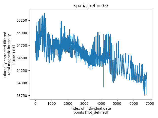
215        standard_name: total_magnetic_intensity
216        long_name: Diurnally corrected filtered total magnetic intensity
217        units: nanoTesla
218        missing_value: not_defined
Add the Gridded Data
Import a tif of gridded mag data. The metadata file for raster datasets should contain paths to the raster files.
d_supp1 = join(data_path, 'WI_Magnetics_grids_md.yml')
gd = data_container.gs.add(key='grids', metadata_file=d_supp1)
Gridded (Raster) Magnetic YAML file
 1dataset_attrs :
 2    content : gridded magnetic maps
 3    comment: contractor-derived maps
 4    type: data
 5    structure: raster
 6    mode: airborne
 7    method: magnetic, total magnetic field
 8    instrument: cesium vapour
 9    property: magnetic
10
11coordinates:
12    x: E_Nad83
13    y: N_Nad83
14
15dimensions:
16    x: E_Nad83
17    y: N_Nad83
18
19variables:
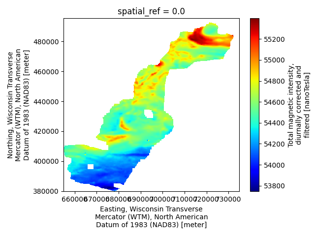
20    magnetic_tmi:
21        standard_name: total_magnetic_intensity
22        long_name: Total magnetic intensity, diurnally corrected and filtered
23        units: nanoTesla
24        missing_value: -9999.99
25        files : Midwest_Core_MAG_TMI_NAD83.tif
26        dimensions: [x, y]
27
28    magnetic_rmf:
29        standard_name: residual_magnetic_field
30        long_name: Residual magnetic field, IGRF corrected from 2015 model
31        units: nanoTesla
32        missing_value: -9999.99
33        files : Midwest_Core_MAG_RMF_NAD83.tif
34        dimensions: [x, y]
35
36    E_Nad83:
37        standard_name: easting_nad83
38        long_name: Easting, Wisconsin Transverse Mercator (WTM), North American Datum of 1983 (NAD83)
39        units: meter
40        missing_value: not_defined
41        axis : x
42
43    N_Nad83:
44        standard_name: northing_nad83
45        long_name: Northing, Wisconsin Transverse Mercator (WTM), North American Datum of 1983 (NAD83)
46        units: meter
47        missing_value: not_defined
48        axis : y
Save to NetCDF file
d_out = join(data_path, 'magnetics.nc')
survey.gs.to_netcdf(d_out)
Opening a GS NetCDF
new_survey = gspy.open_datatree(d_out)['survey']
View the Data Tree
print(new_survey)
<xarray.DataTree 'survey'>
Group: /survey
│   Dimensions:                 ()
│   Coordinates:
│       spatial_ref             float64 8B ...
│   Data variables:
│       survey_information      float64 8B ...
│       flightline_information  float64 8B ...
│       survey_equipment        float64 8B ...
│   Attributes:
│       type:          survey
│       title:         Magnetic data from SkyTEM Airborne Electromagnetic (AEM) S...
│       institution:   USGS Geology, Geophysics, and Geochemistry Science Center
│       source:        SkyTEM raw data, USGS processed data
│       history:       (1) Data acquisition 01/2021 - 02/2021 by SkyTEM Canada In...
│       references:    Minsley, Burke J., B.R. Bloss, D.J. Hart, W. Fitzpatrick, ...
│       comment:       This dataset includes minimally processed (raw) AEM and ra...
│       summary:       Magnetic survey data were collected during January and Feb...
│       content:       Wisconsin SkyTEM survey information /survey; raw flightlin...
│       gspy_version:  2.2.8
│       conventions:   GS-2.0, CF-1.13
└── Group: /survey/magnetic_data
    │   Dimensions:      ()
    │   Data variables:
    │       spatial_ref  float64 8B ...
    │   Attributes:
    │       content:  raw flightline and gridded magnetic data
    │       comment:  grids were contractor-derived
    │       type:     container
    ├── Group: /survey/magnetic_data/raw_data
    │   │   Dimensions:      (index: 6785)
    │   │   Coordinates:
    │   │     * index        (index) float64 54kB 0.0 1.0 2.0 ... 6.783e+03 6.784e+03
    │   │       spatial_ref  float64 8B ...
    │   │       x            (index) float64 54kB ...
    │   │       y            (index) float64 54kB ...
    │   │       z            (index) float64 54kB ...
    │   │   Data variables: (12/17)
    │   │       fid          (index) float64 54kB ...
    │   │       line         (index) float64 54kB ...
    │   │       lon          (index) float64 54kB ...
    │   │       lat          (index) float64 54kB ...
    │   │       alt          (index) float64 54kB ...
    │   │       height       (index) float64 54kB ...
    │   │       ...           ...
    │   │       mag_raw      (index) float64 54kB ...
    │   │       tmi          (index) float64 54kB ...
    │   │       rmf          (index) float64 54kB ...
    │   │       igrf         (index) float64 54kB ...
    │   │       inc          (index) float64 54kB ...
    │   │       dec          (index) float64 54kB ...
    │   │   Attributes:
    │   │       content:     raw data
    │   │       comment:     Contains flightline magnetic data
    │   │       type:        data
    │   │       structure:   tabular
    │   │       mode:        airborne
    │   │       method:      magnetic, total magnetic field
    │   │       instrument:  cesium vapour
    │   └── Group: /survey/magnetic_data/raw_data/magnetic_system
    │           Dimensions:                           (n_transmitter: 1, n_receiver: 1,
    │                                                  n_couplet: 1, n_base_magnetometer: 1,
    │                                                  base_mag_locations: 2)
    │           Coordinates:
    │             * n_transmitter                     (n_transmitter) float64 8B 0.0
    │             * n_receiver                        (n_receiver) float64 8B 0.0
    │             * n_couplet                         (n_couplet) float64 8B 0.0
    │             * n_base_magnetometer               (n_base_magnetometer) float64 8B 0.0
    │             * base_mag_locations                (base_mag_locations) float64 16B 1.0 2.0
    │           Data variables: (12/29)
    │               transmitter_label                 (n_transmitter) <U7 28B ...
    │               transmitter_description           (n_transmitter) <U142 568B ...
    │               receiver_label                    (n_receiver) <U19 76B ...
    │               receiver_sensor_type              (n_receiver) <U23 92B ...
    │               receiver_sensor_model             (n_receiver) <U6 24B ...
    │               receiver_sensor_manufacturer      (n_receiver) <U10 40B ...
    │               ...                                ...
    │               diurnal_correction                <U110 440B ...
    │               tieline_levelling                 <U33 132B ...
    │               microlevelling                    <U31 124B ...
    │               igrf_model_date                   <U21 84B ...
    │               igrf_model_location               <U54 216B ...
    │               igrf_model_height                 <U69 276B ...
    │           Attributes:
    │               type:        system
    │               mode:        airborne
    │               method:      magnetic
    │               instrument:  Geometrics G-822A cesium‑vapor magnetometer
    │               name:        magnetic_system
    └── Group: /survey/magnetic_data/grids
            Dimensions:       (x: 799, nv: 2, y: 1155)
            Coordinates:
              * x             (x) float64 6kB 6.551e+05 6.552e+05 ... 7.348e+05 7.349e+05
              * nv            (nv) float64 16B 0.0 1.0
              * y             (y) float64 9kB 4.953e+05 4.952e+05 ... 3.8e+05 3.799e+05
                spatial_ref   float64 8B ...
            Data variables:
                x_bnds        (x, nv) float64 13kB ...
                y_bnds        (y, nv) float64 18kB ...
                magnetic_tmi  (y, x) float64 7MB ...
                magnetic_rmf  (y, x) float64 7MB ...
            Attributes:
                content:     gridded magnetic maps
                comment:     contractor-derived maps
                type:        data
                structure:   raster
                mode:        airborne
                method:      magnetic, total magnetic field
                instrument:  cesium vapour
                property:    magnetic
Plotting
plt.figure()
new_survey['magnetic_data/raw_data']['height'].plot()
plt.tight_layout()
pd = new_survey['magnetic_data/raw_data']['tmi']
plt.figure()
pd.plot()
plt.tight_layout()
m = new_survey['magnetic_data/grids/magnetic_tmi']
plt.figure()
m.plot(cmap='jet')
plt.tight_layout()

plt.show()
Total running time of the script: (0 minutes 0.542 seconds)