Uses a cross section retrieval web services to retrieve a cross section given a point and specified width. Orientation is determined based on direction of the flowline found near point. This function uses a 10m National Elevation Dataset request on the back end.
get_xs_point(point, width, num_pts)Arguments
Value
sf data.frame containing points retrieved.
Examples
# \donttest{
point <- sf::st_sfc(sf::st_point(x = c(-105.97218, 36.17592)), crs = 4326)
(xs <- get_xs_point(point, 300, 100))
#> POST https://api.water.usgs.gov/nldi/pygeoapi/processes/nldi-xsatpoint/execution
#> {
#> "inputs": [
#> {
#> "id": "lat",
#> "type": "text/plain",
#> "value": "36.17592"
#> },
#> {
#> "id": "lon",
#> "type": "text/plain",
#> "value": "-105.97218"
#> },
#> {
#> "id": "width",
#> "type": "text/plain",
#> "value": "300"
#> },
#> {
#> "id": "numpts",
#> "type": "text/plain",
#> "value": "100"
#> }
#> ]
#> }
#> Simple feature collection with 101 features and 4 fields
#> Geometry type: POINT
#> Dimension: XY
#> Bounding box: xmin: -105.9735 ymin: 36.1757 xmax: -105.9709 ymax: 36.17613
#> Geodetic CRS: WGS 84
#> # A tibble: 101 × 5
#> id spatial_ref elevation_m distance_m geometry
#> <chr> <int> <dbl> <dbl> <POINT [°]>
#> 1 0 0 1772. 0 (-105.9735 36.1757)
#> 2 1 0 1771. 2.40 (-105.9735 36.17571)
#> 3 2 0 1771. 4.81 (-105.9735 36.17571)
#> 4 3 0 1771. 7.21 (-105.9734 36.17572)
#> 5 4 0 1770. 9.61 (-105.9734 36.17572)
#> 6 5 0 1769. 12.0 (-105.9734 36.17572)
#> 7 6 0 1769. 14.4 (-105.9734 36.17573)
#> 8 7 0 1768. 16.8 (-105.9733 36.17573)
#> 9 8 0 1768. 19.2 (-105.9733 36.17574)
#> 10 9 0 1767. 21.6 (-105.9733 36.17574)
#> # ℹ 91 more rows
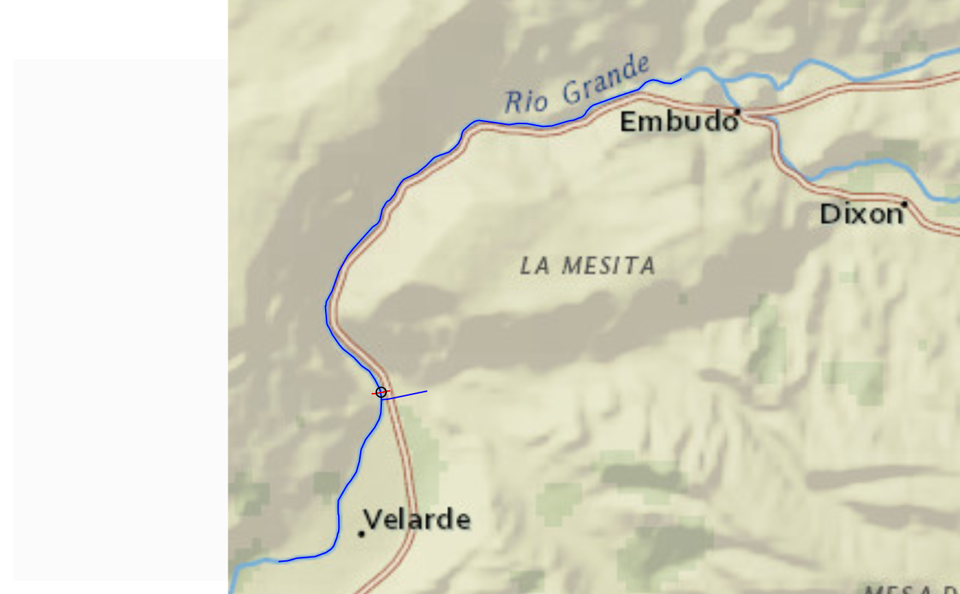
if(inherits(xs, "sf")) {
bbox <- sf::st_bbox(xs) + c(-0.005, -0.005, 0.005, 0.005)
hydrogeofetch::plot_nhdplus(bbox = bbox, cache_data = FALSE)
plot(sf::st_transform(sf::st_geometry(xs), 3857), pch = ".", add = TRUE, col = "red")
plot(sf::st_transform(sf::st_sfc(point, crs = 4326), 3857), add = TRUE)
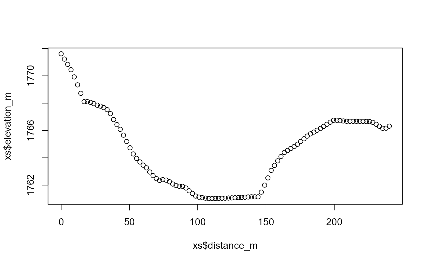
plot(xs$distance_m, xs$elevation_m)
}
#> GET https://api.water.usgs.gov/fabric/pygeoapi/collections/nhdflowline_network/items?bbox=-105.978513816029,36.1707028723172,-105.965870215484,36.1811254899636&limit=500&offset=0
 # }
# }