Saves a subset of the National Seamless database or other
hydrogeofetch compatible data based on a specified collection of COMIDs.
This function uses get_nhdplus for the "download" data
source but returns data consistent with local data subsets in a subset
file.
subset_nhdplus(
  comids = NULL,
  output_file = NULL,
  nhdplus_data = NULL,
  bbox = NULL,
  simplified = TRUE,
  overwrite = FALSE,
  return_data = TRUE,
  status = TRUE,
  flowline_only = NULL,
  streamorder = NULL,
  out_prj = 4269
)
Arguments
- comids
integer vector of COMIDs to include.
- output_file
character path to save the output to defaults to the directory of the nhdplus_data.
- nhdplus_data
character path to the .gpkg or .gdb containing the national seamless database, a subset of NHDPlusHR, or "download" to use a web service to download NHDPlusV2.1 data. Not required if
nhdplus_pathhas been set or the default has been adopted. See details for more.- bbox
object of class "bbox" as returned by sf::st_bbox in Latitude/Longitude. If no CRS is present, will be assumed to be in WGS84 Latitude Longitude.
- simplified
boolean if TRUE (the default) the CatchmentSP layer will be included. Not relevant to the "download" option or NHDPlusHR data.
- overwrite
boolean should the output file be overwritten
- return_data
boolean if FALSE path to output file is returned silently otherwise data is returned in a list.
- status
boolean should the function print status messages
- flowline_only
boolean WARNING: experimental if TRUE only the flowline network and attributes will be returned
- streamorder
integer only streams of order greater than or equal will be downloaded. Not implemented for local data.
- out_prj
character override the default output CRS of NAD83 lat/lon (EPSG:4269)
Value
character path to the saved subset geopackage
Details
This function relies on the National Seamless Geodatabase or Geopackage. It can be downloaded here.
The "download" option of this function should be considered preliminary and subject to revision. It does not include as many layers and may not be available permanently.
Examples
# \donttest{
source(system.file("extdata/sample_data.R", package = "hydrogeofetch"))
nhdplus_path(sample_data)
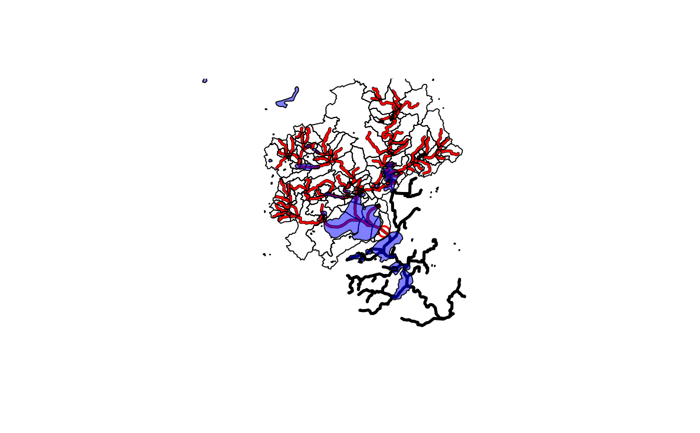
sample_flines <- sf::st_zm(sf::read_sf(nhdplus_path(), "NHDFlowline_Network"))
plot(sf::st_geometry(sample_flines),
lwd = 3)
start_point <- sf::st_sfc(sf::st_point(c(-89.362239, 43.090266)),
crs = 4326)
plot(start_point, cex = 1.5, lwd = 2, col = "red", add = TRUE)
start_comid <- discover_nhdplus_id(start_point)
comids <- hydroloom::navigate_hydro_network(sample_flines, start_comid, "UT")
plot(sf::st_geometry(dplyr::filter(sample_flines, COMID %in% comids)),
add=TRUE, col = "red", lwd = 2)
output_file <- tempfile(fileext = ".gpkg")
subset_nhdplus(comids = comids,
output_file = output_file,
nhdplus_data = sample_data,
overwrite = TRUE,
status = TRUE)
#> $NHDFlowline_Network
#> Simple feature collection with 168 features and 136 fields
#> Geometry type: LINESTRING
#> Dimension: XY
#> Bounding box: xmin: -89.58537 ymin: 43.08521 xmax: -89.21254 ymax: 43.30179
#> Geodetic CRS: GRS 1980(IUGG, 1980)
#> # A tibble: 168 × 137
#> COMID FDATE RESOLUTION GNIS_ID GNIS_NAME LENGTHKM REACHCODE
#> * <int> <dttm> <chr> <chr> <chr> <dbl> <chr>
#> 1 13293750 1999-10-29 00:00:00 Medium 1577073 Yahara Ri… 1.72 07090002…
#> 2 13293504 1999-10-29 00:00:00 Medium 1577073 Yahara Ri… 1.41 07090002…
#> 3 13294134 1999-10-29 00:00:00 Medium 1577073 Yahara Ri… 0.74 07090002…
#> 4 13294128 1999-10-29 00:00:00 Medium 1577073 Yahara Ri… 3.70 07090002…
#> 5 13294394 1999-10-29 00:00:00 Medium 1577073 Yahara Ri… 0.077 07090002…
#> 6 13293454 1999-10-29 00:00:00 Medium 1577073 Yahara Ri… 0.94 07090002…
#> 7 13293430 1999-10-29 00:00:00 Medium 1577073 Yahara Ri… 1.14 07090002…
#> 8 13293424 1999-10-29 00:00:00 Medium 1577073 Yahara Ri… 1.27 07090002…
#> 9 13294110 1999-10-29 00:00:00 Medium 1577073 Yahara Ri… 7.48 07090002…
#> 10 13293398 1999-10-29 00:00:00 Medium 1577073 Yahara Ri… 0.082 07090002…
#> # ℹ 158 more rows
#> # ℹ 130 more variables: FLOWDIR <chr>, WBAREACOMI <int>, FTYPE <chr>,
#> # FCODE <int>, Shape_Length <dbl>, StreamLeve <int>, StreamOrde <int>,
#> # StreamCalc <int>, FromNode <dbl>, ToNode <dbl>, Hydroseq <dbl>,
#> # LevelPathI <dbl>, Pathlength <dbl>, TerminalPa <dbl>, ArbolateSu <dbl>,
#> # Divergence <int>, StartFlag <int>, TerminalFl <int>, DnLevel <int>,
#> # UpLevelPat <dbl>, UpHydroseq <dbl>, DnLevelPat <dbl>, DnMinorHyd <dbl>, …
#>
#> $CatchmentSP
#> Simple feature collection with 167 features and 6 fields
#> Geometry type: GEOMETRY
#> Dimension: XY
#> Bounding box: xmin: -89.60479 ymin: 43.03507 xmax: -89.20378 ymax: 43.36607
#> Geodetic CRS: GRS 1980(IUGG, 1980)
#> # A tibble: 167 × 7
#> GRIDCODE FEATUREID SOURCEFC AreaSqKM Shape_Length Shape_Area
#> * <int> <int> <chr> <dbl> <dbl> <dbl>
#> 1 1085160 13293454 NHDFlowline 0.328 0.0256 0.0000364
#> 2 1085219 13293750 NHDFlowline 6.69 0.148 0.000740
#> 3 1085247 13294134 NHDFlowline 0.261 0.0307 0.0000288
#> 4 1085414 13293570 NHDFlowline 0.0514 0.00963 0.00000569
#> 5 1085447 13293430 NHDFlowline 1.63 0.0780 0.000181
#> 6 1085448 13293526 NHDFlowline 0.0690 0.0117 0.00000764
#> 7 1085463 13293588 NHDFlowline 0.429 0.0404 0.0000475
#> 8 1085478 13293614 NHDFlowline 3.15 0.0953 0.000348
#> 9 1085502 13294264 NHDFlowline 24.8 0.348 0.00275
#> 10 1085509 13293384 NHDFlowline 0.291 0.0296 0.0000323
#> # ℹ 157 more rows
#> # ℹ 1 more variable: geom <GEOMETRY [°]>
#>
#> $NHDArea
#> [1] "NHDArea"
#>
#> $NHDWaterbody
#> [1] "NHDWaterbody"
#>
#> $NHDFlowline_NonNetwork
#> [1] "NHDFlowline_NonNetwork"
#>
#> $Gage
#> [1] "Gage"
#>
#> $Sink
#> NULL
#>
sf::st_layers(output_file)
#> Driver: GPKG
#> Available layers:
#> layer_name geometry_type features fields crs_name
#> 1 NHDFlowline_Network Line String 168 136 GRS 1980(IUGG, 1980)
#> 2 CatchmentSP 167 6 GRS 1980(IUGG, 1980)
#> 3 NHDArea Polygon 1 14 GRS 1980(IUGG, 1980)
#> 4 NHDWaterbody Polygon 90 21 GRS 1980(IUGG, 1980)
#> 5 NHDFlowline_NonNetwork Line String 45 12 GRS 1980(IUGG, 1980)
#> 6 Gage Point 33 19 GRS 1980(IUGG, 1980)
catchment <- sf::read_sf(output_file, "CatchmentSP")
plot(sf::st_geometry(catchment), add = TRUE)
waterbody <- sf::read_sf(output_file, "NHDWaterbody")
plot(sf::st_geometry(waterbody),
col = rgb(0, 0, 1, alpha = 0.5), add = TRUE)
 # Cleanup temp
unlink(output_file)
# Download Option:
subset_nhdplus(comids = comids,
output_file = output_file,
nhdplus_data = "download",
overwrite = TRUE,
status = TRUE, flowline_only = FALSE)
#> $NHDFlowline_Network
#> Simple feature collection with 168 features and 138 fields
#> Geometry type: LINESTRING
#> Dimension: XY
#> Bounding box: xmin: -89.58537 ymin: 43.08522 xmax: -89.21254 ymax: 43.3018
#> Geodetic CRS: NAD83
#> # A tibble: 168 × 139
#> objectid comid fdate resolution gnis_id gnis_name lengthkm
#> * <int> <int> <dttm> <chr> <chr> <chr> <dbl>
#> 1 969053 13293376 1999-10-28 23:00:00 Medium " " " " 3.04
#> 2 969052 13293378 1999-10-28 23:00:00 Medium " " " " 1.44
#> 3 968961 13293380 1999-10-28 23:00:00 Medium "1577073" "Yahara … 4.84
#> 4 969050 13293382 1999-10-28 23:00:00 Medium " " " " 4.40
#> 5 968960 13293384 1999-10-28 23:00:00 Medium "1577073" "Yahara … 0.839
#> 6 969051 13293386 1999-10-28 23:00:00 Medium " " " " 4.67
#> 7 968959 13293388 1999-10-28 23:00:00 Medium "1577073" "Yahara … 0.402
#> 8 969049 13293390 1999-10-28 23:00:00 Medium " " " " 1.08
#> 9 968958 13293392 1999-10-28 23:00:00 Medium "1577073" "Yahara … 1.12
#> 10 969055 13293394 1999-10-28 23:00:00 Medium " " " " 0.351
#> # ℹ 158 more rows
#> # ℹ 132 more variables: reachcode <chr>, flowdir <chr>, wbareacomi <int>,
#> # ftype <chr>, fcode <int>, shape_length <dbl>, streamleve <dbl>,
#> # streamorde <dbl>, streamcalc <dbl>, fromnode <dbl>, tonode <dbl>,
#> # hydroseq <dbl>, levelpathi <dbl>, pathlength <dbl>, terminalpa <dbl>,
#> # arbolatesu <dbl>, divergence <dbl>, startflag <dbl>, terminalfl <dbl>,
#> # dnlevel <dbl>, uplevelpat <dbl>, uphydroseq <dbl>, dnlevelpat <dbl>, …
#>
#> $CatchmentSP
#> Simple feature collection with 167 features and 7 fields
#> Geometry type: MULTIPOLYGON
#> Dimension: XY
#> Bounding box: xmin: -89.6048 ymin: 43.03507 xmax: -89.20379 ymax: 43.36608
#> Geodetic CRS: NAD83
#> # A tibble: 167 × 8
#> objectid gridcode featureid sourcefc areasqkm shape_length shape_area
#> * <int> <int> <int> <chr> <dbl> <dbl> <dbl>
#> 1 947947 1085160 13293454 NHDFlowline 0.328 0.0256 0.0000364
#> 2 948005 1085219 13293750 NHDFlowline 6.69 0.148 0.000740
#> 3 948032 1085247 13294134 NHDFlowline 0.261 0.0307 0.0000288
#> 4 948197 1085414 13293570 NHDFlowline 0.0514 0.00963 0.00000569
#> 5 948230 1085447 13293430 NHDFlowline 1.63 0.0780 0.000181
#> 6 948231 1085448 13293526 NHDFlowline 0.0690 0.0117 0.00000764
#> 7 948246 1085463 13293588 NHDFlowline 0.429 0.0404 0.0000475
#> 8 948261 1085478 13293614 NHDFlowline 3.15 0.0953 0.000348
#> 9 948284 1085502 13294264 NHDFlowline 24.8 0.348 0.00275
#> 10 948291 1085509 13293384 NHDFlowline 0.291 0.0296 0.0000323
#> # ℹ 157 more rows
#> # ℹ 1 more variable: geometry <MULTIPOLYGON [°]>
#>
#> $NHDArea
#> Simple feature collection with 1 feature and 15 fields
#> Geometry type: POLYGON
#> Dimension: XY
#> Bounding box: xmin: -89.40195 ymin: 43.15017 xmax: -89.36132 ymax: 43.18113
#> Geodetic CRS: NAD83
#> # A tibble: 1 × 16
#> objectid comid fdate resolution gnis_id gnis_name areasqkm
#> * <int> <int> <dttm> <chr> <chr> <chr> <dbl>
#> 1 5849 14711352 1999-10-28 23:00:00 Medium " " " " 1.36
#> # ℹ 9 more variables: elevation <dbl>, ftype <chr>, fcode <int>,
#> # shape_length <dbl>, shape_area <dbl>, onoffnet <int>, purpcode <chr>,
#> # purpdesc <chr>, geometry <POLYGON [°]>
#>
#> $NHDWaterbody
#> Simple feature collection with 90 features and 22 fields
#> Geometry type: POLYGON
#> Dimension: XY
#> Bounding box: xmin: -89.7288 ymin: 42.98971 xmax: -89.2094 ymax: 43.40396
#> Geodetic CRS: NAD83
#> # A tibble: 90 × 23
#> objectid comid fdate resolution gnis_id gnis_name areasqkm
#> * <int> <int> <dttm> <chr> <chr> <chr> <dbl>
#> 1 194410 13284192 1999-10-28 23:00:00 Medium "1573793" "Schoenb… 0.473
#> 2 195149 13284194 1999-10-28 23:00:00 Medium " " " " 0.022
#> 3 194411 13284200 1999-10-28 23:00:00 Medium " " " " 0.045
#> 4 194412 13284204 1999-10-28 23:00:00 Medium " " " " 0.062
#> 5 195170 13284246 1999-10-28 23:00:00 Medium " " " " 0.035
#> 6 195171 13284270 1999-10-28 23:00:00 Medium " " " " 0.01
#> 7 194415 13284290 1999-10-28 23:00:00 Medium " " " " 0.008
#> 8 195335 13293126 2009-04-30 23:00:00 Medium "1565651" "Goose L… 0.077
#> 9 194583 13293128 1999-10-28 23:00:00 Medium " " " " 0.123
#> 10 195151 13293178 1999-10-28 23:00:00 Medium " " " " 0.021
#> # ℹ 80 more rows
#> # ℹ 16 more variables: elevation <dbl>, reachcode <chr>, ftype <chr>,
#> # fcode <int>, shape_length <dbl>, shape_area <dbl>, onoffnet <int>,
#> # purpcode <chr>, purpdesc <chr>, meandepth <dbl>, lakevolume <dbl>,
#> # maxdepth <dbl>, meandused <dbl>, meandcode <chr>, lakearea <dbl>,
#> # geometry <POLYGON [°]>
#>
#> $NHDFlowline_NonNetwork
#> Simple feature collection with 45 features and 13 fields
#> Geometry type: LINESTRING
#> Dimension: XY
#> Bounding box: xmin: -89.62331 ymin: 43.04215 xmax: -89.25272 ymax: 43.35875
#> Geodetic CRS: NAD83
#> # A tibble: 45 × 14
#> objectid comid fdate resolution gnis_id gnis_name lengthkm
#> * <int> <int> <dttm> <chr> <chr> <chr> <dbl>
#> 1 109402 13293368 1999-10-28 19:00:00 Medium " " " " 2.34
#> 2 109458 13293370 1999-10-28 19:00:00 Medium " " " " 0.106
#> 3 109467 13293374 1999-10-28 19:00:00 Medium " " " " 1.33
#> 4 109401 13293402 1999-10-28 19:00:00 Medium " " " " 0.097
#> 5 109410 13293408 1999-10-28 19:00:00 Medium " " " " 2.45
#> 6 109455 13293414 1999-10-28 19:00:00 Medium " " " " 2.26
#> 7 109403 13293466 1999-10-28 19:00:00 Medium " " " " 1.52
#> 8 109454 13293470 1999-10-28 19:00:00 Medium " " " " 3.94
#> 9 109411 13293482 1999-10-28 19:00:00 Medium " " " " 1.52
#> 10 109406 13293500 1999-10-28 19:00:00 Medium " " " " 2.90
#> # ℹ 35 more rows
#> # ℹ 7 more variables: reachcode <chr>, flowdir <chr>, wbareacomi <int>,
#> # ftype <chr>, fcode <int>, shape_length <dbl>, geometry <LINESTRING [°]>
#>
sf::st_layers(output_file)
#> Driver: GPKG
#> Available layers:
#> layer_name geometry_type features fields crs_name
#> 1 NHDFlowline_Network Line String 168 138 NAD83
#> 2 CatchmentSP Multi Polygon 167 7 NAD83
#> 3 NHDArea Polygon 1 15 NAD83
#> 4 NHDWaterbody Polygon 90 22 NAD83
#> 5 NHDFlowline_NonNetwork Line String 45 13 NAD83
# NHDPlusHR
source(system.file("extdata/nhdplushr_data.R", package = "hydrogeofetch"))
up_ids <- hydroloom::navigate_hydro_network(hr_data$NHDFlowline, 15000500028335, "UT")
#> defaulting to comid rather than permanent_identifier
sub_gpkg <- file.path(work_dir, "sub.gpkg")
sub_nhdhr <- subset_nhdplus(up_ids, output_file = sub_gpkg,
nhdplus_data = hr_gpkg, overwrite = TRUE)
sf::st_layers(sub_gpkg)
#> Driver: GPKG
#> Available layers:
#> layer_name geometry_type features fields crs_name
#> 1 NHDFlowline Line String 1427 57 GRS 1980(IUGG, 1980)
#> 2 NHDPlusCatchment 1361 7 GRS 1980(IUGG, 1980)
#> 3 NHDArea Polygon 8 14 GRS 1980(IUGG, 1980)
#> 4 NHDWaterbody Polygon 740 15 GRS 1980(IUGG, 1980)
names(sub_nhdhr)
#> [1] "NHDFlowline" "NHDPlusCatchment" "NHDArea" "NHDWaterbody"
#> [5] "NHDPlusSink"
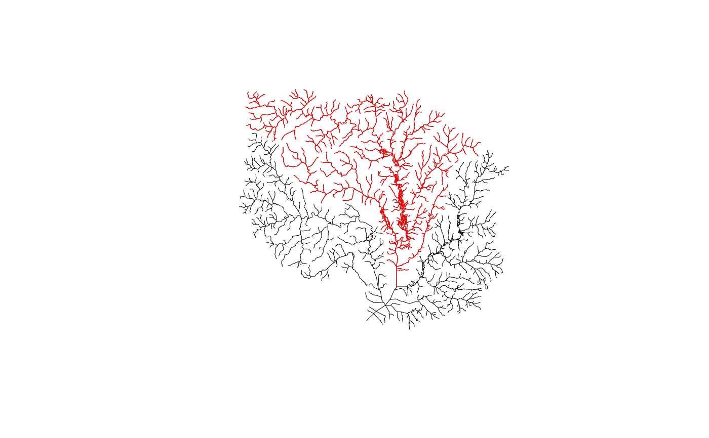
plot(sf::st_geometry(hr_data$NHDFlowline), lwd = 0.5)
plot(sf::st_geometry(sub_nhdhr$NHDFlowline), lwd = 0.6, col = "red", add = TRUE)
# Cleanup temp
unlink(output_file)
# Download Option:
subset_nhdplus(comids = comids,
output_file = output_file,
nhdplus_data = "download",
overwrite = TRUE,
status = TRUE, flowline_only = FALSE)
#> $NHDFlowline_Network
#> Simple feature collection with 168 features and 138 fields
#> Geometry type: LINESTRING
#> Dimension: XY
#> Bounding box: xmin: -89.58537 ymin: 43.08522 xmax: -89.21254 ymax: 43.3018
#> Geodetic CRS: NAD83
#> # A tibble: 168 × 139
#> objectid comid fdate resolution gnis_id gnis_name lengthkm
#> * <int> <int> <dttm> <chr> <chr> <chr> <dbl>
#> 1 969053 13293376 1999-10-28 23:00:00 Medium " " " " 3.04
#> 2 969052 13293378 1999-10-28 23:00:00 Medium " " " " 1.44
#> 3 968961 13293380 1999-10-28 23:00:00 Medium "1577073" "Yahara … 4.84
#> 4 969050 13293382 1999-10-28 23:00:00 Medium " " " " 4.40
#> 5 968960 13293384 1999-10-28 23:00:00 Medium "1577073" "Yahara … 0.839
#> 6 969051 13293386 1999-10-28 23:00:00 Medium " " " " 4.67
#> 7 968959 13293388 1999-10-28 23:00:00 Medium "1577073" "Yahara … 0.402
#> 8 969049 13293390 1999-10-28 23:00:00 Medium " " " " 1.08
#> 9 968958 13293392 1999-10-28 23:00:00 Medium "1577073" "Yahara … 1.12
#> 10 969055 13293394 1999-10-28 23:00:00 Medium " " " " 0.351
#> # ℹ 158 more rows
#> # ℹ 132 more variables: reachcode <chr>, flowdir <chr>, wbareacomi <int>,
#> # ftype <chr>, fcode <int>, shape_length <dbl>, streamleve <dbl>,
#> # streamorde <dbl>, streamcalc <dbl>, fromnode <dbl>, tonode <dbl>,
#> # hydroseq <dbl>, levelpathi <dbl>, pathlength <dbl>, terminalpa <dbl>,
#> # arbolatesu <dbl>, divergence <dbl>, startflag <dbl>, terminalfl <dbl>,
#> # dnlevel <dbl>, uplevelpat <dbl>, uphydroseq <dbl>, dnlevelpat <dbl>, …
#>
#> $CatchmentSP
#> Simple feature collection with 167 features and 7 fields
#> Geometry type: MULTIPOLYGON
#> Dimension: XY
#> Bounding box: xmin: -89.6048 ymin: 43.03507 xmax: -89.20379 ymax: 43.36608
#> Geodetic CRS: NAD83
#> # A tibble: 167 × 8
#> objectid gridcode featureid sourcefc areasqkm shape_length shape_area
#> * <int> <int> <int> <chr> <dbl> <dbl> <dbl>
#> 1 947947 1085160 13293454 NHDFlowline 0.328 0.0256 0.0000364
#> 2 948005 1085219 13293750 NHDFlowline 6.69 0.148 0.000740
#> 3 948032 1085247 13294134 NHDFlowline 0.261 0.0307 0.0000288
#> 4 948197 1085414 13293570 NHDFlowline 0.0514 0.00963 0.00000569
#> 5 948230 1085447 13293430 NHDFlowline 1.63 0.0780 0.000181
#> 6 948231 1085448 13293526 NHDFlowline 0.0690 0.0117 0.00000764
#> 7 948246 1085463 13293588 NHDFlowline 0.429 0.0404 0.0000475
#> 8 948261 1085478 13293614 NHDFlowline 3.15 0.0953 0.000348
#> 9 948284 1085502 13294264 NHDFlowline 24.8 0.348 0.00275
#> 10 948291 1085509 13293384 NHDFlowline 0.291 0.0296 0.0000323
#> # ℹ 157 more rows
#> # ℹ 1 more variable: geometry <MULTIPOLYGON [°]>
#>
#> $NHDArea
#> Simple feature collection with 1 feature and 15 fields
#> Geometry type: POLYGON
#> Dimension: XY
#> Bounding box: xmin: -89.40195 ymin: 43.15017 xmax: -89.36132 ymax: 43.18113
#> Geodetic CRS: NAD83
#> # A tibble: 1 × 16
#> objectid comid fdate resolution gnis_id gnis_name areasqkm
#> * <int> <int> <dttm> <chr> <chr> <chr> <dbl>
#> 1 5849 14711352 1999-10-28 23:00:00 Medium " " " " 1.36
#> # ℹ 9 more variables: elevation <dbl>, ftype <chr>, fcode <int>,
#> # shape_length <dbl>, shape_area <dbl>, onoffnet <int>, purpcode <chr>,
#> # purpdesc <chr>, geometry <POLYGON [°]>
#>
#> $NHDWaterbody
#> Simple feature collection with 90 features and 22 fields
#> Geometry type: POLYGON
#> Dimension: XY
#> Bounding box: xmin: -89.7288 ymin: 42.98971 xmax: -89.2094 ymax: 43.40396
#> Geodetic CRS: NAD83
#> # A tibble: 90 × 23
#> objectid comid fdate resolution gnis_id gnis_name areasqkm
#> * <int> <int> <dttm> <chr> <chr> <chr> <dbl>
#> 1 194410 13284192 1999-10-28 23:00:00 Medium "1573793" "Schoenb… 0.473
#> 2 195149 13284194 1999-10-28 23:00:00 Medium " " " " 0.022
#> 3 194411 13284200 1999-10-28 23:00:00 Medium " " " " 0.045
#> 4 194412 13284204 1999-10-28 23:00:00 Medium " " " " 0.062
#> 5 195170 13284246 1999-10-28 23:00:00 Medium " " " " 0.035
#> 6 195171 13284270 1999-10-28 23:00:00 Medium " " " " 0.01
#> 7 194415 13284290 1999-10-28 23:00:00 Medium " " " " 0.008
#> 8 195335 13293126 2009-04-30 23:00:00 Medium "1565651" "Goose L… 0.077
#> 9 194583 13293128 1999-10-28 23:00:00 Medium " " " " 0.123
#> 10 195151 13293178 1999-10-28 23:00:00 Medium " " " " 0.021
#> # ℹ 80 more rows
#> # ℹ 16 more variables: elevation <dbl>, reachcode <chr>, ftype <chr>,
#> # fcode <int>, shape_length <dbl>, shape_area <dbl>, onoffnet <int>,
#> # purpcode <chr>, purpdesc <chr>, meandepth <dbl>, lakevolume <dbl>,
#> # maxdepth <dbl>, meandused <dbl>, meandcode <chr>, lakearea <dbl>,
#> # geometry <POLYGON [°]>
#>
#> $NHDFlowline_NonNetwork
#> Simple feature collection with 45 features and 13 fields
#> Geometry type: LINESTRING
#> Dimension: XY
#> Bounding box: xmin: -89.62331 ymin: 43.04215 xmax: -89.25272 ymax: 43.35875
#> Geodetic CRS: NAD83
#> # A tibble: 45 × 14
#> objectid comid fdate resolution gnis_id gnis_name lengthkm
#> * <int> <int> <dttm> <chr> <chr> <chr> <dbl>
#> 1 109402 13293368 1999-10-28 19:00:00 Medium " " " " 2.34
#> 2 109458 13293370 1999-10-28 19:00:00 Medium " " " " 0.106
#> 3 109467 13293374 1999-10-28 19:00:00 Medium " " " " 1.33
#> 4 109401 13293402 1999-10-28 19:00:00 Medium " " " " 0.097
#> 5 109410 13293408 1999-10-28 19:00:00 Medium " " " " 2.45
#> 6 109455 13293414 1999-10-28 19:00:00 Medium " " " " 2.26
#> 7 109403 13293466 1999-10-28 19:00:00 Medium " " " " 1.52
#> 8 109454 13293470 1999-10-28 19:00:00 Medium " " " " 3.94
#> 9 109411 13293482 1999-10-28 19:00:00 Medium " " " " 1.52
#> 10 109406 13293500 1999-10-28 19:00:00 Medium " " " " 2.90
#> # ℹ 35 more rows
#> # ℹ 7 more variables: reachcode <chr>, flowdir <chr>, wbareacomi <int>,
#> # ftype <chr>, fcode <int>, shape_length <dbl>, geometry <LINESTRING [°]>
#>
sf::st_layers(output_file)
#> Driver: GPKG
#> Available layers:
#> layer_name geometry_type features fields crs_name
#> 1 NHDFlowline_Network Line String 168 138 NAD83
#> 2 CatchmentSP Multi Polygon 167 7 NAD83
#> 3 NHDArea Polygon 1 15 NAD83
#> 4 NHDWaterbody Polygon 90 22 NAD83
#> 5 NHDFlowline_NonNetwork Line String 45 13 NAD83
# NHDPlusHR
source(system.file("extdata/nhdplushr_data.R", package = "hydrogeofetch"))
up_ids <- hydroloom::navigate_hydro_network(hr_data$NHDFlowline, 15000500028335, "UT")
#> defaulting to comid rather than permanent_identifier
sub_gpkg <- file.path(work_dir, "sub.gpkg")
sub_nhdhr <- subset_nhdplus(up_ids, output_file = sub_gpkg,
nhdplus_data = hr_gpkg, overwrite = TRUE)
sf::st_layers(sub_gpkg)
#> Driver: GPKG
#> Available layers:
#> layer_name geometry_type features fields crs_name
#> 1 NHDFlowline Line String 1427 57 GRS 1980(IUGG, 1980)
#> 2 NHDPlusCatchment 1361 7 GRS 1980(IUGG, 1980)
#> 3 NHDArea Polygon 8 14 GRS 1980(IUGG, 1980)
#> 4 NHDWaterbody Polygon 740 15 GRS 1980(IUGG, 1980)
names(sub_nhdhr)
#> [1] "NHDFlowline" "NHDPlusCatchment" "NHDArea" "NHDWaterbody"
#> [5] "NHDPlusSink"
plot(sf::st_geometry(hr_data$NHDFlowline), lwd = 0.5)
plot(sf::st_geometry(sub_nhdhr$NHDFlowline), lwd = 0.6, col = "red", add = TRUE)
 unlink(output_file)
unlink(sub_gpkg)
# }
unlink(output_file)
unlink(sub_gpkg)
# }